Goodbye, Mardi Gras

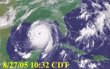
Hurricane Katrina is bearing down upon the City of New Orleans as a Category 5 storm, with sustained winds of 175 mph. We dodged a bullet here, when Katrina dropped to the south and hit Ft. Lauderdale/Miami as a Category 1. Eleven people died because of the storm (and because of their own stupidity).
The hurricane then headed up the Gulf of Mexico, picking up speed over the warm water. We are now expecting the worst and costliest natural disaster in the history of this country. New Orleans is already six feet below sea level, with a series of levees keeping the water in check. No one expects them to hold. All highways leading out of New Orleans have been made one way only. Residents and tourists are flooding out of the city, causing major traffic jams. All hotels within 8 hours drive are filled.
Where Katrina makes landfall, coastal storm surge flooding of 18 to 22 feet above normal tide levels is anticipated. It may reach as high as 28 feet in some places, along with large and dangerous battering waves. Hurricane force winds will reach farther inland than anyone can recall any hurricane reaching along its path. Katrina also has the potential to cause flooding from the coast to the St. Lawrence Seaway.
God help them.
Update:
URGENT - WEATHER MESSAGE
NATIONAL WEATHER SERVICE NEW ORLEANS LA
10:11 AM CDT SUN AUG 28 2005
...DEVASTATING DAMAGE EXPECTED...
.HURRICANE KATRINA...A MOST POWERFUL HURRICANE WITH UNPRECEDENTED STRENGTH...RIVALING THE INTENSITY OF HURRICANE CAMILLE OF 1969.
MOST OF THE AREA WILL BE UNINHABITABLE FOR WEEKS...PERHAPS LONGER. AT LEAST ONE HALF OF WELL CONSTRUCTED HOMES WILL HAVE ROOF AND WALL FAILURE. ALL GABLED ROOFS WILL FAIL...LEAVING THOSE HOMES SEVERELY DAMAGED OR DESTROYED.
THE MAJORITY OF INDUSTRIAL BUILDINGS WILL BECOME NON FUNCTIONAL. PARTIAL TO COMPLETE WALL AND ROOF FAILURE IS EXPECTED. ALL WOOD FRAMED LOW RISING APARTMENT BUILDINGS WILL BE DESTROYED. CONCRETE BLOCK LOW RISE APARTMENTS WILL SUSTAIN MAJOR DAMAGE...INCLUDING SOME WALL AND ROOF FAILURE.
HIGH RISE OFFICE AND APARTMENT BUILDINGS WILL SWAY DANGEROUSLY...A FEW TO THE POINT OF TOTAL COLLAPSE. ALL WINDOWS WILL BLOW OUT.
AIRBORNE DEBRIS WILL BE WIDESPREAD...AND MAY INCLUDE HEAVY ITEMS SUCH AS HOUSEHOLD APPLIANCES AND EVEN LIGHT VEHICLES. SPORT UTILITY VEHICLES AND LIGHT TRUCKS WILL BE MOVED. THE BLOWN DEBRIS WILL CREATE ADDITIONAL DESTRUCTION. PERSONS...PETS...AND LIVESTOCK EXPOSED TO THE WINDS WILL FACE CERTAIN DEATH IF STRUCK.
POWER OUTAGES WILL LAST FOR WEEKS...AS MOST POWER POLES WILL BE DOWN AND TRANSFORMERS DESTROYED. WATER SHORTAGES WILL MAKE HUMAN SUFFERING INCREDIBLE BY MODERN STANDARDS.
THE VAST MAJORITY OF NATIVE TREES WILL BE SNAPPED OR UPROOTED. ONLY THE HEARTIEST WILL REMAIN STANDING...BUT BE TOTALLY DEFOLIATED. FEW CROPS WILL REMAIN. LIVESTOCK LEFT EXPOSED TO THE WINDS WILL BE KILLED.
AN INLAND HURRICANE WIND WARNING IS ISSUED WHEN SUSTAINED WINDS NEAR HURRICANE FORCE...OR FREQUENT GUSTS AT OR ABOVE HURRICANE FORCE...ARE CERTAIN WITHIN THE NEXT 12 TO 24 HOURS.
ONCE TROPICAL STORM AND HURRICANE FORCE WINDS ONSET...DO NOT VENTURE OUTSIDE!
Labels: hurricanes

2 Comments:
Glad to hear you dodged Katrina. Ft. Lauderdale was mentioned the other day on the news here - and I was scared to ask you, reckoning new posts meant no bad news affecting you personally.
I feel for those in the way of this now. Your commentary is terrifying, but extremely informative and explanatory, with a human touch (much better than what we get here on the news).
Thanks, Colin. I'm a nervous wreck, thinking about those poor people. They're saying this is a once in 500 years event. There will be many, many deaths.
Post a Comment
<< Home